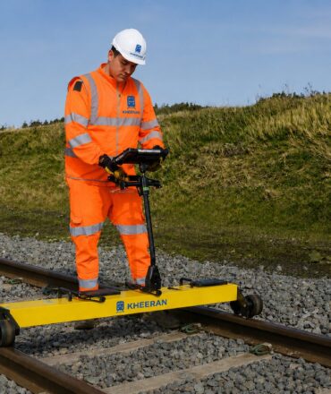
No single technology tells you everything about a railway corridor. A combined GPR, geometry and LiDAR railway survey gives a complete picture — what lies beneath the rail, how the track rides, and what stands beside it. Kheeran brings all three together in a single campaign, so maintenance planners get integrated, chainage-referenced data from one mobilisation. According to the Federal Railroad Administration, integrated track inspection data is fundamental to proactive maintenance planning.
1. GPR ballast investigation
Ground Penetrating Radar maps ballast fouling, clean-ballast thickness and trapped water continuously along the track — non-destructively and at hi-rail speed. It answers the question conventional inspection cannot: what is the condition of the substructure between the boreholes? Furthermore, multi-frequency GPR provides both shallow high-resolution and deep subgrade penetration in a single pass.
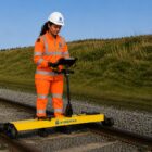
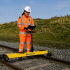
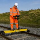
2. Rail track geometry
Geometry measurement captures gauge, alignment, twist, cross-level and surface, referenced to your chainage. Trended between campaigns, it shows where the track is deteriorating — and, paired with GPR, whether the cause is fouled ballast, trapped water or formation failure. Additionally, geometry data feeds directly into FRA compliance reporting and tamping priority lists.
3. LiDAR corridor asset scanning
Mobile LiDAR captures the complete corridor in three dimensions — every signal, platform, bridge, vegetation encroachment and clearance limit. Point cloud classification produces an asset inventory and structure-gauge analysis without repeated site visits. However, the real power comes when LiDAR, GPR and geometry data are all referenced to the same chainage, creating a single queryable record of corridor condition.
Why a combined GPR, geometry and LiDAR railway survey saves money
Running three separate survey campaigns means three track possessions, three mobilisations and three data handoffs. A combined campaign cuts possession time, reduces cost per kilometre, and delivers data that cross-references — so a geometry defect can be immediately investigated against the GPR fouling profile at the same chainage. This integration is what turns survey data into maintenance decisions.
Ready to plan a combined survey? Talk to Kheeran about your corridor.